Friday, October 16, 2026
When should I do my winter tire swap?
After last weekend's storm, we're quickly thawing out and it looks like beautiful weather for this weekend. Hope you all are able to get out and enjoy it! The topic of today's post is something I've seen floating around the interwebs and a common question around town this time of year: When should I do my winter tire swap? I'm going to try to answer this with a bit of science and the latest weather forecasts.
We technically already had our first snowfall, with some road accumulation, in the last storm. However, road conditions only seemed dicey for maybe ~12-18 hours during the worst of the snow late Sun - early Mon. For those that held out and haven't swapped yet, you will be rewarded :). More on that in a bit. I should also add a couple of caveats here that may affect decision making. If you have to commute over a higher-elevation pass like Bozeman Pass, for instance, that probably bumps up these timelines a bit. Also, a lot likely depends on the traction quality of your current tire set. If you already have decent All-season tires, that allows for more risk tolerance. Okay, let's get into the #s!
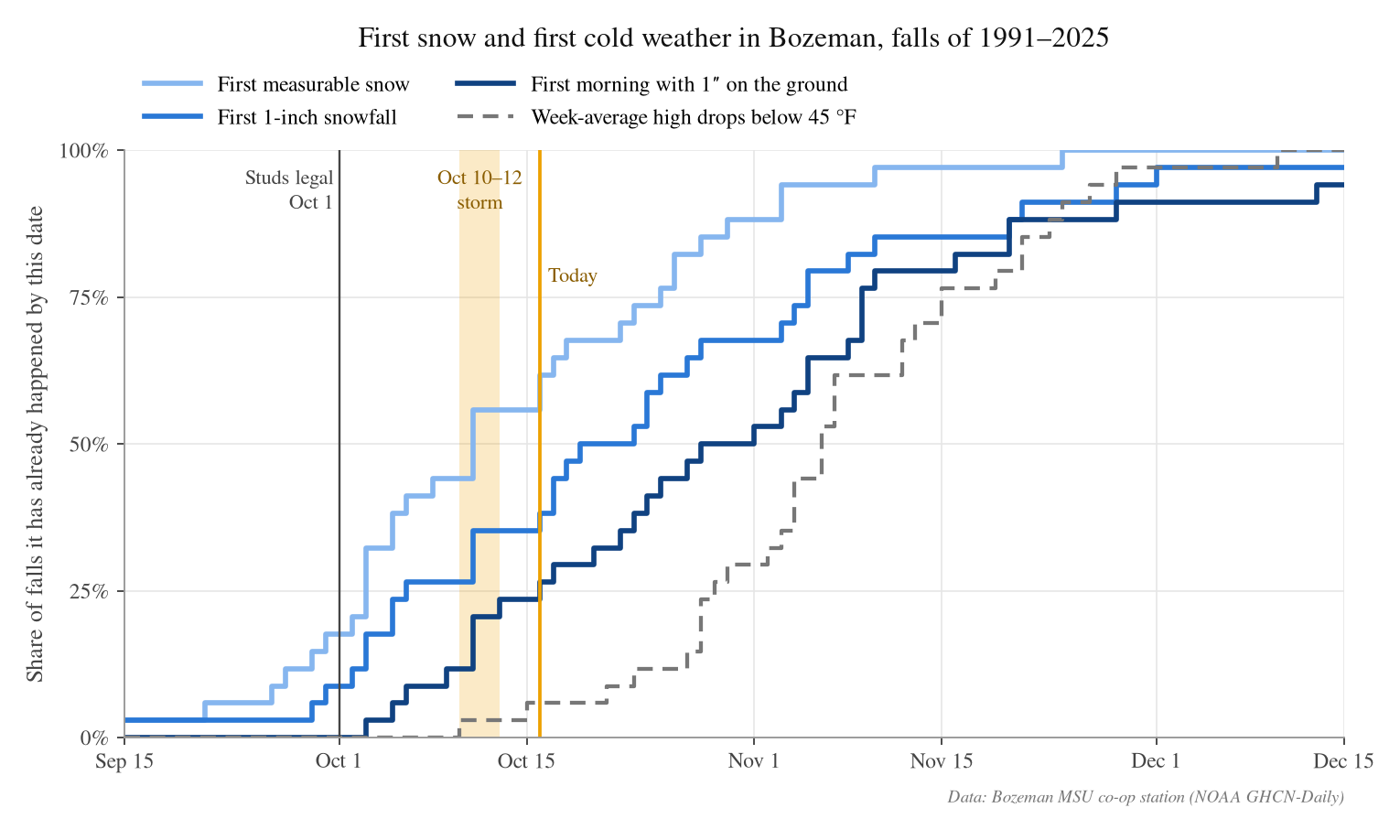
For the Oct 10–12 storm you can see that we were right at the typical date for the first snowfall, but about 10 days ahead of schedule for the first 1-inch snowfall. Week-average highs dropping below 45ºF is used here as a rough threshold for when snow starts sticking to roads more easily, since colder road surfaces collect snow more effectively. Typically early November is when those temperatures are consistently colder.
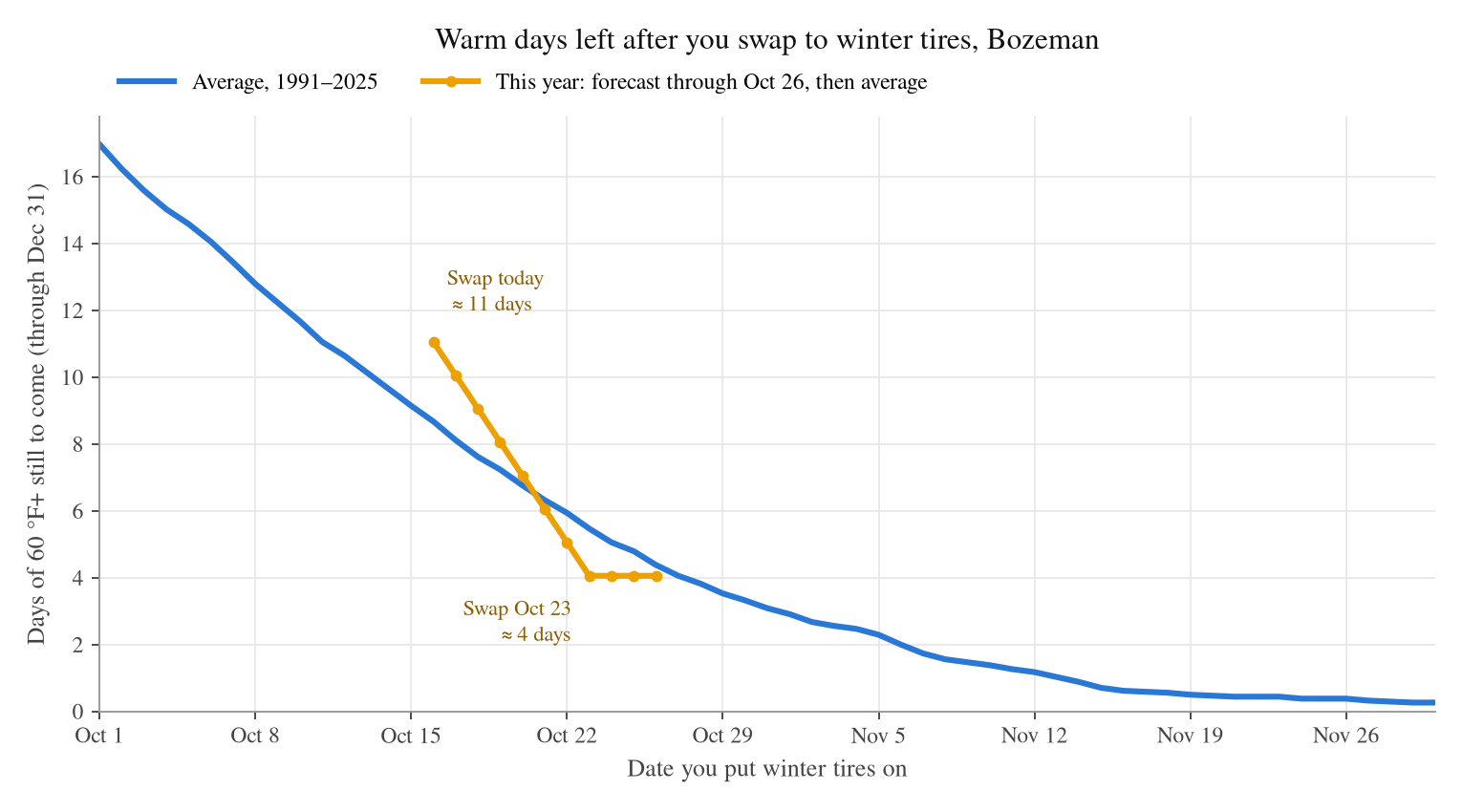
Another consideration is the number of "warm days" left (from both a climatological and forecast standpoint). Basically, with the warmer weather that's expected over the next 5–7 days, we're still expecting another 10+ days with highs over 60ºF for the remainder of this year. More than half of these are this next week. With this information, if you're able to hold out, waiting at least another week, maybe 2 would prevent you from driving on warmer roads (and potentially wearing down your tires a bit faster). If you're not driving a lot, it's probably no biggie, but if you are, it's worth factoring in, in addition to increased fuel costs if you swap to winter tires too early. Overall, my recommendation would be the last week of October or first week of November for those that mostly do in town driving. For those with more mountain driving (or current tires aren't great), I'd recommend changing them out here sometime in the next week.
Finally, looking at the current forecast, it's likely we'll be above average in terms of temperatures for the next ~week before we may see our next storm system late next week. The next chance for colder weather and any potential snow looks to be Thursday night through Saturday (Oct 22–24). There’s a lot of uncertainty with the models right now: ECMWF and its ensembles are more aggressive, showing a 72% chance of >0.25” of water (44% chance of at least .25” falling as snow, which would be 2-3” in the Bridgers). The GFS ensembles, on the other hand, only show a 32% (16%) probability of decent precipitation. For those that aren't familiar with ensembles, I'll leave the details for a future post but they're essentially a model that's run with several slightly different combinations of either the initial state or model parameters. This is done because we know there are deficiencies in both the model and characterization of the initial atmosphere (a model's starting point). This allows us to get a more realistic spread of potential outcomes.
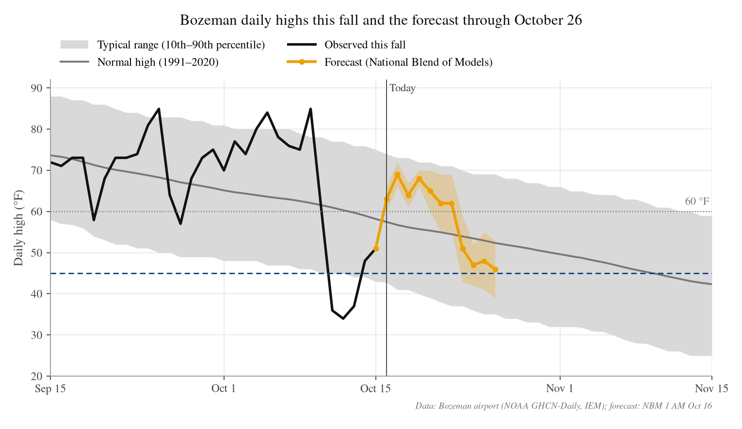
We’ll keep an eye on things heading into early next week as the forecast evolves. Hope everyone has a great weekend!
-Trey
Comments