Wednesday, October 7, 2026
Weekend Snow
Thanks, all, for the warm reception to the launch of this blog! It makes me excited that so many in our community are interested in the weather. Today’s post will cover this weekend’s potential storm. ❄️ ⛷🏂
It’s hard to believe with how warm it’s been over this past week (we’re just a few degrees shy of record highs for the date), but we may be talking about the potential for enough snow to ski early next week (at least for those with rock skis and flexible ACLs). Wait, what? Skiing already? Let me start off by saying that this is a very complex forecast. Why? We have a traditional frontal / mid-latitude storm system moving in from the west, but it’ll also be interacting with Hurricane Rachel that will be moving northward from the eastern Pacific.
On Saturday PM a strong cold front will move through bringing heavy mountain precipitation that should quickly transition to snow at all elevations. Both the ECMWF (European weather model) and Google DeepMind (AI model) are trending more bullish with potential snowfall. Below is UofUtah’s downscaled snow ensemble (meaning it uses the large global GFS and ECMWF models and tries to “downscale” or extrapolate what precipitation might look like on smaller scales due to terrain effects, etc.). The GEFS and ECMWF ensembles in the Utah Snow Ensemble graphics below both show a mean of > 1" of water content. For early season storms we generally want more water content (less cold smoke) to help build our base.
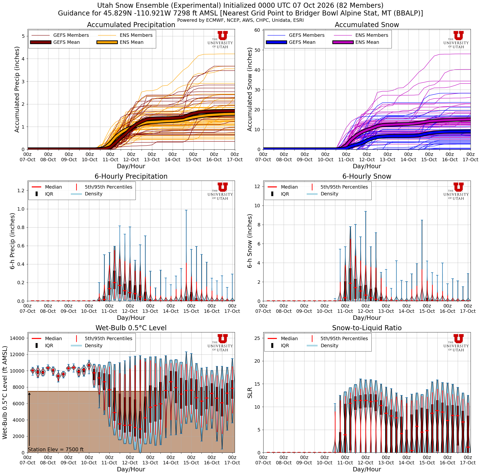
In the plots above you can see that both the GEFS and ECMWF ensembles are generally in decent agreement with the water content but less so on overall snowfall amounts. This is because the GEFS is quite a bit warmer than the ECMWF ensembles. Though I can’t completely discount that solution, it seems like it’s more of an outlier and I’d maybe lean towards the colder solutions with more snowfall based on current guidance.
With this, my current expectations would be 6–12”+ for the upper mountains at Bridger and Big Sky. Also, I think there's a decent likelihood of our first in-town snow in Bozeman overnight Saturday. Note that the IFS and GFS operational runs keep things a bit warmer and drier, which would make these totals lower. At this time, though, those models seem to be outliers. There's a pretty strong precipitation gradient from northwest - southeast that I'm keeping an eye on as well. I’ll also add that this is a quite complex forecast due to the interactions of multiple features here. Furthermore, I’d expect decreased predictability overall in the upcoming pattern for the next 2+ weeks. A former professor of mine writes a very interesting Utah-based blog (also helps run weather.utah.edu, where I got the plume graphic from) with a recent post on how western Pacific typhoons may be affecting the pattern downstream over the Intermountain West: https://wasatchweatherweenies.blogspot.com/2026/10/how-to-break-jet-stream.html.
And for the hardcore weather nerds: https://agupubs.onlinelibrary.wiley.com/doi/full/10.1002/2015GL065082
Thanks for reading!
-Trey
P.S. for our friends farther west near Missoula and the Bitterroots, totals look a bit lighter.
Comments